An Aurum Meum Gold Map brings geology, structure, and terrain together to explain where gold occurs and why.
What Is an Aurum Meum Gold Map?
If you’ve ever asked why gold appears in one place but not another, then you’re already thinking in geological terms and therefore an Aurum Meum Gold Map can take you to the next level of Gold Prospecting. Aurum Meum Gold maps are designed to answer that question clearly. Plus, instead of relying on guesswork, they show how gold behaves across real landscapes so then, as a result, prospectors can plan with confidence before stepping into the field.
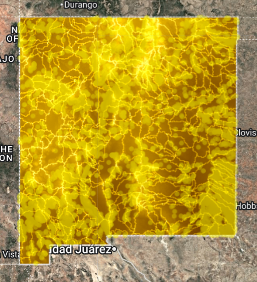
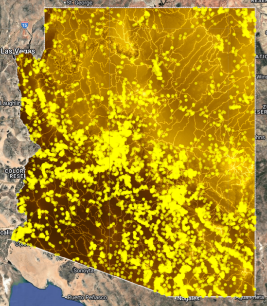
Example: A state-level gold probability plus structure interpretation from New Mexico all contained within a single Aurum Meum Gold Map so prospectors can therefore be more productive in the field.
Understanding Gold Maps and Gold Mapping Systems
Modern gold mapping focuses on relationships rather than isolated locations. So therefore, understanding how structure, terrain, plus erosion interact provides far more value than simple pin-drop maps.
What Information These Maps Use
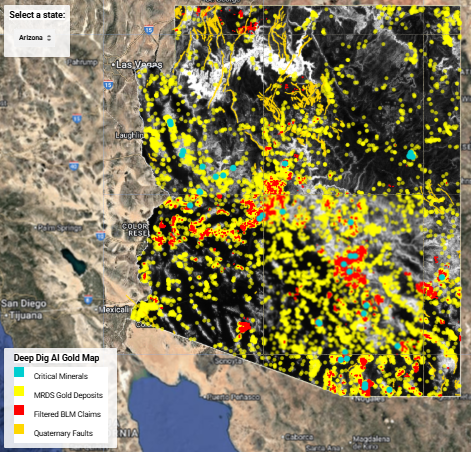
Each Aurum Meum map is built from carefully selected public datasets. Furthermore, these include documented mineral occurrences, geological structure, plus drainage systems sourced from organizations such as the U.S. Geological Survey. As a result, the information remains grounded in real science.
- Documented gold occurrences and mining districts
- Faults, shear zones, plus structural controls
- Terrain and elevation data
- Drainage systems that transport heavy minerals
How Prospectors Apply Gold Maps
First, prospectors narrow their focus to historically productive regions then they compare structural plus terrain patterns across districts. Ultimately, this approach replaces random searching with deliberate planning.
- Choose a proven state
- Compare structural trends
- Evaluate terrain plus drainage
- Verify targets in the field
To explore these tools further, visit our Gold Maps overview or browse individual state gold maps to see how patterns differ across regions.
For additional geological context, the Aurum Meum AI Academy on YouTube provides publicly available Forensic Gold Geology Lessons plus effective gold maps used by professionals worldwide.
Watch how an Aurum Meum Gold Map mapping system explains gold occurrence using geological structure, terrain and then repeating patterns so anyone can find gold in nature by following the gold maps direction.
How an Aurum Meum Gold Map Works
First, an Aurum Meum Gold Map starts with geology, not guesses. Therefore, instead of focusing only on past discoveries, the map examines the conditions that allow gold to form, move, and concentrate. In other words, it explains the process behind gold occurrence rather than showing only the end result.
Next, structural features are layered into the map. For example, faults, shear zones, and deformation belts often act as pathways for mineral-rich fluids. Consequently, areas where these structures intersect favorable rock types receive higher attention. As a result, large regions can be narrowed into smaller, more meaningful targets.
Then, terrain and surface processes are added to the picture. Specifically, erosion, slope changes, and drainage patterns influence where gold is released and redeposited. Therefore, understanding landscape evolution becomes just as important as knowing where gold originated. Ultimately, this step connects hardrock sources to placer opportunities.
Why Gold Maps Are More Than Pin Drops
Historically, many maps showed only mine locations or reported finds. However, dots alone rarely explain why those locations exist. Because of this, relying solely on pin-based maps often leads to wasted time and unfocused searching.
Instead, an Aurum Meum Gold Map emphasizes relationships. For instance, when geology, structure, and terrain align, recognizable patterns begin to repeat across districts. Consequently, prospectors can move beyond random exploration and begin planning with confidence.
In Summary
An Aurum Meum Gold Map is not about guaranteeing gold. Instead, it helps explain how gold behaves across real terrain then, by combining geology, structure, and landscape evolution. Plus, these maps reduce wasted time and support therefore it results in smarter exploration.