AI-powered Gold Prospecting With a Human Touch
Find Gold Faster With AI-Powered Prospecting Maps
Aurum Meum AI helps prospectors reduce guesswork by combining geology, terrain, drainage patterns, historic mining data, mineral records, and AI-supported interpretation into practical gold prospecting tools.
Choose your state to start with an interactive map built for better trip planning and stronger prospecting decisions.

Know the Landscape. Find the Gold.
Gold is rarely random. It is controlled by geology, structure, erosion, water movement, weathering, and time. Aurum Meum AI helps you study those patterns before you spend money on fuel, gear, lodging, or field time.
Our goal is not to give you a magic pin. Our goal is to help you understand which ground deserves attention first.
Start With the Tool That Fits Your Search
State AI Gold Maps
Best for prospectors who want broad coverage, repeat use, and a map they can study over time.
$27 Gold Location Report
Best when you want help narrowing one area into practical starting targets.
$97 Elite Report
Best when you want a deeper interpretation with marked map views and stronger field strategy.
How Aurum Meum AI Helps
1. Choose Ground
Start with a state, county, creek, district, or area of interest.
2. Read Patterns
Review terrain, drainage, mineral records, and historic mining context.
3. Narrow Targets
Focus on stronger zones before entering the field.
4. Prospect Smarter
Use better information to reduce wasted trips and weak ground.
Not Sure Where to Begin?
Start with a custom report if you already have a creek, claim area, district, county, or town in mind. We help turn that location into a more informed prospecting plan.
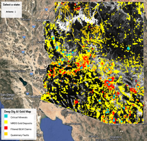
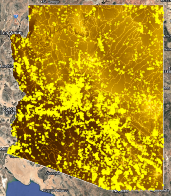
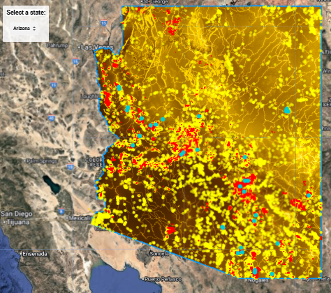
Featured Deep Dig V2 Example
Deep Dig V2 maps are built to help prospectors compare broad patterns and identify areas worth closer review. The Arizona example shows how terrain, structure, drainage, and mineral context can be interpreted together.

Popular Prospecting States
These states are common starting points because of historic production, known districts, placer history, or strong mineral patterns.
- Nevada — major gold belts and mining history.
- Alaska — famous placer districts and broad gold footprint.
- California — classic goldfields and placer systems.
- Arizona — desert washes, lode districts, and placer potential.
- Colorado — historic camps and mountain drainage systems.
- Montana — placer heritage and district-scale systems.
- Idaho — proven placer and hardrock regions.
- Oregon — known gold-bearing streams and districts.
Learn the Method Behind the Maps
Aurum Meum AI Academy teaches the geology behind gold. Learn how faults, fractures, hydrothermal fluids, placer systems, supergene enrichment, rivers, benches, and terrain relationships affect where gold can concentrate.
Official YouTube Channel
Gold Geology, Mapping, and Field Logic
Watch lessons, map walkthroughs, and prospecting strategy videos built to help you understand the ground before you go.
Early Customer Feedback
— Randall Brink
Frequently Asked Questions
Do AI gold maps guarantee gold?
No. These are decision-support tools. They help narrow stronger ground, but field testing, legal access, sampling, and verification are still required.
What is the best way to start?
Choose your state first. Use the map to study broad patterns. Add a report when you want help narrowing a specific location.
What is the difference between a map and a report?
The map is the tool. The report is the interpretation. Use the map to explore and the report to focus.
Can these help with placer gold?
Yes. They can help compare drainage systems, stream patterns, historic placer areas, and terrain that may influence gold concentration.
Can these help with claim research?
They can help identify interesting ground, but always verify land ownership, claim status, access rules, and local regulations through official sources.
Get Aurum Meum Updates
Join for new map releases, prospecting lessons, report updates, member map drops, and field-tested gold prospecting ideas.